2010 End Of May Scout Trip Out of Magnetawan Lake
2010 End Of May Scout Trip Out of Magnetawan Lake |
|
History Last year's plans for a weeklong summer trip were changed as often as the baby's underwear but we had fun putting up an early target and then seeing how much the actual trip deviated from those early expectations. For 2010 we had developed some trip ideas out of Magnetawan Lake Access, a starting point which we like for the many routes that can be developed for our skills, health status and the variety of water, i.e., small lakes, ponds, rivers, creeks along with larger lakes. The options were relatively flat, something we desire due to age and a few noisy, gimpy knees. Almost every May for over a decade Baron and Jester have paddled around the time of the US Memorial Day long weekend. We look forward to heading north and totally changing our routine for a few days. This year we were both retired and decided to extend our time in the bush. Also we had three basic trip routes and wanted to paddle the region to confirm our memories in light of the ten years that had passed since we last paddled Daisy to Misty and nearby lakes. Over time, both the summer weeklong and the May trip morphed into options on our options however daily distance, with a couple of exceptions, would be closer to two thirds of our goals from 10 years ago. We felt these distances were legitimate as we've done all of the various trip segments in the past. With this flux as the backdrop to our “scout trip”, Baron and Jester left Cleveland to find some answers. Day One We bunked at Algonquin Outfitters the day before heading off to Huntsville for breakfast and then the drive north to Kearney where we paid for our permit and then drove the remaining distance to the Magnetawan Lake Access. The forest road was in good shape and we were pleased to be on the water at 9:20 AM. I suspect 5 minutes or less is all it took to reach the Hambone portage landing. It's a nice small beach and a very good trail over hard packed dirt and smooth rock before descending down to the water level at the Hambone end. Since our last trip, we noticed a widening of the trail as it drops down over the last 40 fee or so due to people walking around the rocks that might be slick in wet conditions. 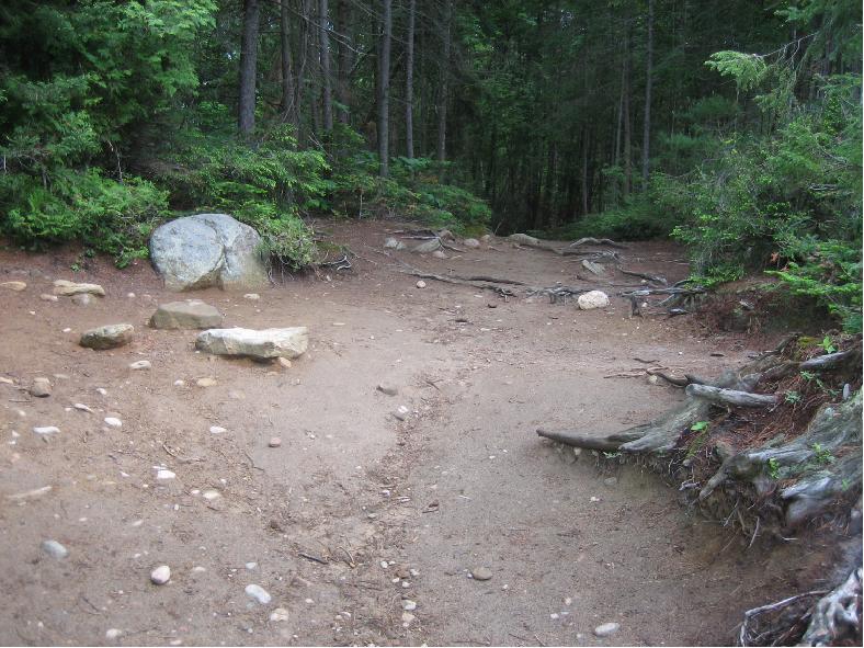 The trail leading from Magnetawan to Hambone from the Magnetawan end. The water level was significantly lower than normal. However, we found that we could sneak through the rocks and take the creek route out of Hambone into what the current FOA canoe routes map incorrectly shows as an unnamed pond. According to the original topo maps, this little body of water is Acme Lake. Whatever name you use, it is worth checking the creek. Usually, if you can get past the first of the rocks at the north end, you can do what we did and pick your way into the creek, stay center and finally veer left to go around the end of a fallen tree. We should be so lucky in July. Although our plan was to paddle all the way to Misty, when we stopped at the northern end of Daisy for lunch. We looked at each other and recognized that we were being affected by the heat and it would be wise to stay put for the day. It is about a 2 1/2 hour paddle and portage from the access to the north end of Daisy if you walk the portages twice over as we did. Of the two sites at the northern end, the better one is on the south shore as you turn right or east. There are several spots for tents and rigging of tarps, a nice balance of shade and sun, plus a nice rock down by the water, which makes for a great place to relax without the aid of a pad or chair. 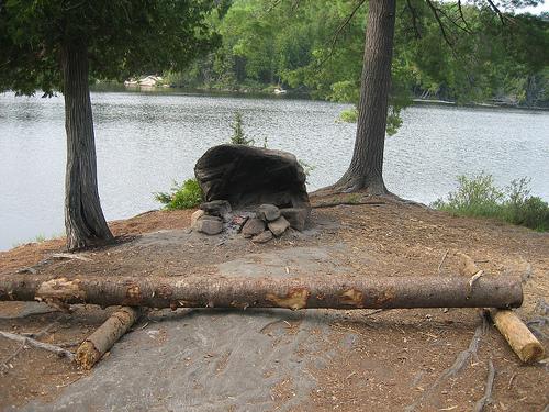 Standing with my back to the wooded tent areas, out to the bare rocks and fire area. 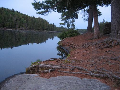 The stillness for which we all search! I spent time reading, but soon dozed off in my hammock. Baron read out on the rocks but kept following the shade. We really were whupped. We watched the eastern sky build and noted that the winds, which during the morning and through mid-day had been out of the north, had now started to shift. Eventually we battened down the gear as we saw a blow coming right at us from the direction of Misty. The tarp was pushed almost flat as the blow reached us but we did not get rain. Day Two In the morning we awoke to the sound of rain. As it turned out, we ended up sticking around the site for the day. I realized that I was still pretty tired and actually light headed. Although I had kept myself hydrated by drinking over 2 liters of filtered water, I was all too eager to head for the hammock when the weather cleared.  The nearest site to ours was across the narrows and west ... ... but it is less pleasant and only adequate for multiple tents. Day Three I carried the canoe on the first and shortest of the three portages between Daisy and Misty. However, Baron did most of the heavy lifting as I was light headed a few times on this day and was really huffing uphill. During our run down the Petawawa we stopped at the small, very scruffy site on Little Misty Lake. I agree with the observation that it is suitable for a hammock. Several trees have been blown down around the site and geese have used the grass as a bathroom so it is not a pleasant spot. We made our sandwiches and then found just enough grass to rest a bit as we headed to Misty. We left Daisy about 9:30 AM and reached Misty at 3 PM, just in time to get a heavy sprinkle. We paddled around the corner, to follow the north western shoreline to the first campsite and retreated under the trees. At 3:15 we agreed to give the rain until 3:30 and then decide whether to push on to investigate other sites around the lake. We had used this site back in 2000 and it's a better option than the next site up the shoreline to the north. Eventually, we set up the Buckley Dry Fly and our tent. Once again, I quickly climbed into the hammock, while Baron dug out his fishing rod and reel. I caught some ZZZZZs which turned out to be more than Baron's catch. Day Four The following day we made a day trip east to Misty's southeastern end. We took the short portage, which begins at an awkward rocky landing, continues up a steep but somewhat short, hill and then over an easy trail to the creek that leads into Timberwolf Lake. While not bad for a single canoe, this route to and from Timberwolf might not be suitable for a group, as only one canoe at a time can be unloaded and its load must then be moved up the hill before the next canoe can be positioned. We enjoyed this route but we were scouting for a larger group which was set to paddle our route in July and August. If using Jeffrey McMurtrie's digital map (version 2), note the portage trail begins right at the creek mouth and not further east as shown. I have contacted Jeff in this regard. The creek and bay into Timberwolf is nice, and on this day our weather was perfect. A light breeze followed us through the morning and we were soon portaging from Timberwolf over to McIntosh. I recalled to Baron that in 2001 when we came through this area, we encountered a young man who was carrying a large 2 litre bottle of Coke. One of our group told the fellow that his warm Coke was mighty tempting but the young man could not tell if King was serious and his prized possession was in danger or if this truly was a joke. 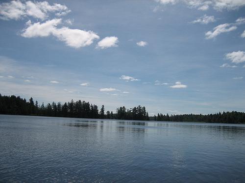 McIntosh as seen from the Mc end of the Timberwolf to McIntosh portage. Maps seem to show one island and a peninsula but we counted 2 islands and paddled between them on our way in and out. Due to the low water this year, we found that most of the campsites on McIntosh that we investigated had somewhat awkward landings, with a difficult step up. We found some that were totally unappealing, some that were adequate and one that was appealing but tough to access. We remembered one nice site near the McIntosh Creek portage where we had lunch in 2001 and we marked our maps accordingly. We stopped for lunch at a mainland campsite on the north shore. After an awkward exit from the canoe, we enjoyed the view of the islands while we ate our flat bread sandwiches of on the spot chicken salad made from foil pouch chicken, relish and mayo. We chose to take the two more direct portages back to Misty and although I was still affected by either the heat or a bug of some kind, I carried the canoe (a Bell Carbon Kevlar layup Chestnut Prospector) the second half of the Timberwolf to Misty portage. You guessed it. Upon returning to our site, I was soon in my hammock. But first, I checked to see if the large turtle we had seen several times was back laying more eggs. Several times we saw this turtle. On one occasion, Baron saw two up on the rocky shoreline trenching or poking holes in the soil. 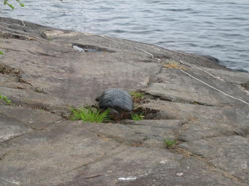 Believe it or not, there was enough soil in the depression for the turtle to bury eggs here, as well as at more suitable spots. Day Five We eventually began our return upstream on the Petawawa. We made much better time, in part due to eating several days of food and I was feeling stronger. We took about 45 minutes less to reach our original campsite on the northern end of Daisy. There was one beaver dam somewhere near the middle portage (don't hold me to this location), where people have been dragging their canoes around the dam along the shore. While we went down river by climbing out and on to the dam, we took the shore route on the way back up stream. Normally we would have stepped out on the dam both ways. But Baron wanted to try the drag-the-canoe method. Eventually we were back on Daisy and enjoying the same site that had been our home the first couple of nights. We set up our gear slowly, but then noticed the clouds were changing and darkening. So we got the tent up but left the Buckley packed, as we wanted to get an early start in the AM. During the night, it rained from about 9:15 PM until around 3 AM. Day Six By daybreak, the weather was OK. We packed up dry and headed off through Daisy, north through Hambone Creek and the unnamed pond, then around the bend on Hambone Lake to the portage, and then back into Magnetawan Lake. We went south to north through Hambone Creek, which is to the west of the portage. Once past the tree by staying right, you can paddle the center of the creek and then carefully navigate around the rocks at the exit and then continue on to the main portion of Hambone Lake. 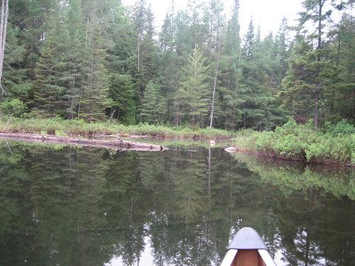 I was feeling better and we made good time this last day and we cut off about 15 to 20 minutes from the 2 1/2 hours we needed on day one to cover the same distance. The only moose seen was on the forest road on our way out when a gangling fellow trotted diagonally across the road from left to right and away from us. The road was in great shape. On the way in, it had slowly gone from 40 MPH down to 30 MPH, finally down to 20 MPH as we got closer to the parking lot. On the way out, we encountered a road grader but we encountered no other vehicles on the road. Approximately 4 other vehicles had been in the lot both upon our arrival and on the day we pulled out. It was another successful trip, though different from what was intended. We changed our route due to our experience with the heat, the water levels and even experimented with our menu. It is much easier to bury two paddlers who could not survive their own cooking than it is to placate a larger group who don't appreciate the concept of menu adjustments. During our trip we discussed the advantages of implementing what we have for years called the “short day one” idea. In past years, using a shuttle for our summer trips, we have found that we arrive at Magnetawan closer to 10:30 and then end up having lunch on Daisy before spending the afternoon paddling down the Petawawa to Misty where we arrive later than we would prefer. Sometimes we have had great campsites but on other occasions we had to accept what was available. I recall one trip when we were delayed on the river and made camp in the fading light. To avoid that we decided to plan on spending the first night on Daisy, essentially making what was originally day one a two-day segment. We’d have easy portages on day one and a couple of easy portages and the longer Little Misty to Misty portage on day two. Another decision was to abandon the “in and out” trip and to substitute with shuttles .. starting at access 3 (Mag.) and ending at access 5 (Canoe Lake). This actually would allow us to paddle from Misty to McIntosh, then through Grassy Bay to White Trout and then enjoy a layover day on Big Trout .. finishing up the trip by paddling the easy route through The Otterslides, Burnt Island Lake and the Joes before ending at Canoe Lake. 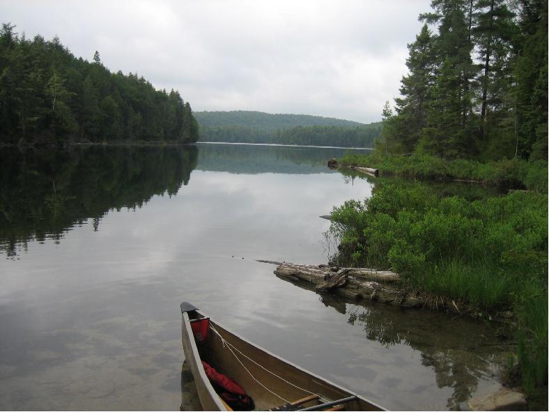 Magnetawan Lake as seen from the Magnetawan end of the Hambone portage. The other lesson learned was .. when you are in extremely hot weather, even when you think you are drinking sufficient quantities of water, drink more. I had not been light headed on previous canoe trips but that first day I did not recognize how dehydrated I had become. The strong breezes fooled me as I did not perspire as I normally do and while I drank 32 ounces by the end of lunch, I could have swallowed another Nalgene bottle and possibly mitigated my fluid loss which caused my extreme weariness for several days. Towards the end of the trip one of us regularly asked the other if we needed a water break or we were reminding one another that it was time for sun block. So the “scout trip” was an opportunity to scout out our own strengths and weaknesses as much as it was a chance to refresh our memories about the waters and woods through which we wanted to travel. Jester |