Algonquin Park Spring Trip .. May 27 – 31, 2005
Route taken:
(Put-in) Access #2 Tim River – Tim Lake – Chibiabos Lake – Indian Pipe Lake – West Koko Pond – Big Bob Lake – Nipissing River – Loontail Creek – Latour Creek – Floating Heart Lake – Rosebary Lake – Tim River – Tim Lake – Tim River – Access #2 (Take-out). (PLEASE NOTE: The portages on this route are designated as "low maintenance". However, I have been on numerous "regular" portage trails in the park which were no better or no worse.)
Weather:
(Saturday) Mid-day highs 20C to 23C (68F to 73F) / night-time low of 12C (54F) / wind light and variable / clear conditions day and night / no precipitation / humidity 30% to 40%
(Sunday) Mid-day highs 19C to 21C (66F to 70F) / nighttime low of 9C (48F) / wind light and variable / clear conditions day and night / no precipitation / humidity 30% to 40%
(Monday) Mid-day highs 21C to 24C (70F to 75F) / wind continues light and variable / clear in AM but clouds building during day / light rain started at 2:00 PM, then off and on all day / big thunderstorms nearby (but they missed us)
Canoes:
One Swift Kipawa tandem canoe(16.5', 45 Lbs.); rented from Algonquin Outfitters at their downtown Huntsville location. (AO is headquartered at Oxtongue Lake near the west entrance of Algonquin P.P. just off Highway 60.)
Paddlers:
One 56 year old male (Neil) and one 21 year old female (Emily), father and daughter (PLEASE NOTE: This is the first time Emily and I have paddled in the same canoe together since 1994 when she was 10 years old and entering middle school. Just to put some perspective on it, in 2006 she enters med school.)
Portage Detail:
Double carried all portages (First trip with primary gear and second with boat and food pack)
Trip timing:
5/27/05: Departed Birmingham (Michigan) at 8:00 AM . . ate breakfast in Shelby Township and crossed border at Port Huron/Sarnia with no delays . . Ate lunch at Severn River Inn about 23 Km north of Orillia on Hwy. 11 . . arrived Kearney at 3:00 PM to pick up park registration . . arrived at AO Huntsville to load canoes at 4:30 PM . . checked into Rainbow Inn Huntsville ($68 CDN) . . went for cocktails and dinner at 5:30 PM at The Cottage Restaurant. 5/28/05: Woke up at 6:30 AM . . quick showers, then breakfast at a place on central Main Street . . arrived Access #2 9:00 AM, 4 other cars in parking lot . . put-in at 9:30 AM . . arrived P345, north side of Tim Lake at 10:10 AM . . arrived P320 east end of Chibiabos Lake at 10:45 . . arrived P820, north west end of Indian Pipe Lake at 11:45 AM . . arrived P790, north side of West Koko Pond at 1:00 PM . . arrived P200, east end of Big Bob lake at 2:15 PM (ate lunch at take-out) . . arrived Nipissing River put-in at 3:00 PM . . arrived P65 around dam at 3:45 PM . . arrived P65 rapids at 4:15 PM . . arrived P55 around waterfall at 4:30 PM and set up Camp 1 at the site there. 5/29/05: Departed Camp 1 at 9:30 AM . . arrived P200 past campsite at 10:45 AM . . arrived P100 around rapids at 11:15 AM . . passed campsite below these rapids on rivers edge at 11:45 AM . . arrived P240 at 3:15 PM . . arrived Grass Lake campsite at 4:30 PM and set up Camp 2. 5/30/05: Departed Camp 2 at 8:30 AM . . entered Loontail Creek at 8:50 AM . . passed Loontail Creek campsite at 9:30 . . arrived P845, into Latour Creek at 10:15 AM . . arrived P1370, into Floating Heart Lake at 12:30 PM . . arrived P365, into Rosebary Lake at 2:30 PM . . ate lunch at nearest campsite, just east of trail, on Rosebary Lake at 3:00 PM . . shoved off into Rosebary Lake at 3:30 PM . . entered Tim River at 3:45 PM . . crossed Little Butt Lake at 4:30 PM . . arrived P120 at 5:45 PM . . entered Tim Lake at 6:15 PM . . entered Tim River at 7:00 PM . . reached take-out at Access #2 at 7:25 PM.
Distance covered:
(From the GPS) Total paddle distance: 48.6 Km (29 miles) . . total portage distance 5,900 meters (x 3
Detail (Saturday, 5/28/05):
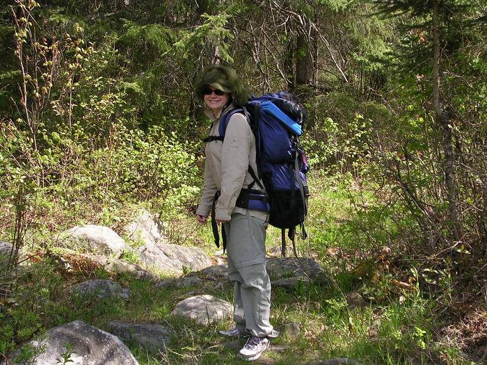
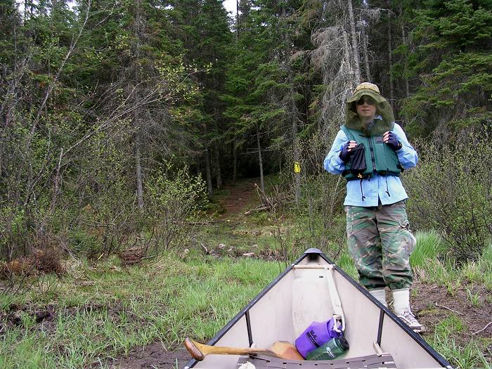
After spending Friday night in a Huntsville motel, the Rainbow Inn, we arose at 6:30 AM, got breakfast at a restaurant on Main street (right across from the old Huntsville City Hall) and arrived at the Tim River Access #2 around 9:00 AM. We had chased a large bull moose down the road on the way to the access and there were two more moose in the backwaters of the Tim on the opposite side of the bridge from the put-in. We put in at 9:30 AM and covered the short section of the Tim River to Tim Lake in 30 minutes. The Tim Lake crossing took another 10 minutes and we arrived at the P345, into Chibiabos Lake at 10:10 AM. Tim Lake was fairly empty but there was a single canoe with two guys fishing. The most significant thing about the trip so far was the large swarms of Black Flies. Emily and I had put on long pants, long sleeves and head nets from the moment we got out of the car and the two fishermen on the lake were also dressed accordingly. This portage trail was nothing too difficult; although just like last year, there were some wet spots.
Last year we went in and out of black flies but so far the black flies were solid on the water and the mosquitoes were solid on the trails. The mosquitoes seemed to have recently hatched because there were a lot of them and at times there were clouds of them. We didn’t fully comprehend it this early on but we were to never remove our long pants, long-sleeve shirts or head-nets for the duration of this trip. We arrived at P320 at 10:45 AM. This 'port' had a ramshackle wooden dock that came out to the water’s edge but the water level was obviously low and we had to walk in the squishy, wet ground to get to the dock. We both suffered wet feet and if you weren’t watching you would step into a very loose spot and go over your shoe in black muck. About halfway along this portage there was also a very permanent, overbuilt- looking lumber road that the portage trail crossed.
We crossed Indian Pipe Lake that was a pretty little lake with no campsites and arrived at P820 at 11:45 AM. It was a steep trail right after takeout but after that it was a good trail with minimal wet spots. Crossing West Koko Pond we arrived at P790 at 1:00 PM. There was a long steady uphill out of the takeout and this 'port' had some unavoidable mucky spots which we had to bypass. Last year there had been some deadfall across this trail but the Backcountry Rangers had cleared them out.
Big Bob Lake looked like a decent lake with 3 campsites but we never checked out the sites and arrived at the P200 takeout at 2:15 PM. There were a lot of blackflies and a lot of mosquitoes but we ate lunch at the takeout anyway. This consisted of herb seasoned tuna on soft taco bread accompanied by Pringles and trail mix. We had to lift our head nets to take every bite and we let in a fair amount of both biting insects. This would be the continuing story of this entire trip right up until we got into our car and drove away. I should state that I believe it is a more than fair trade-off to deal with the little pests in exchange for late spring in the park. My daughter always finds the best in everything and she just resigned herself to long sleeves and head-nets. These insects really didn’t steal any of our enjoyment for the trip but they were constantly prevalent.
We put in on the Nipissing River at 3:00 PM. The upper part of this river winds through a large marsh and I quickly realized that the water was lower this year than last because much of the time the channel was no wider than our canoe forcing us to pole the boat along. We also encountered as many as 12 beaver dams in this relatively short stretch and this slowed us down considerably. We only encountered a couple dams the year before so either the beavers did a lot more building in the interval or last year’s deeper water submerged them. In spite of these "difficulties", this was still an enjoyable stretch of river with many birds and wildlife and before we left this meandering marshy stretch we encountered another bull moose.
We could see the trees slowly close in on the river and when they were right at the shore, at 3:45 PM, we came to the P65 that is marked with a "D" (for Dam) symbol on the map. This was an old timber low- head dam and we made quick work of the portage and then at 4:15 PM we came to the second P65 around a set of rapids spilling over an unnavigable rock garden. This was a very picturesque portage and we met four guys who had made their camp on Tim Lake but who had paddled back in here to fish. They had caught a pretty good sized string of fish but I forgot to ask them what kind they were. They were just loading up for the paddle back to Tim Lake when we arrived. After they had departed, it occurred to me that Emily was wearing a baggy long-sleeve shirt, her life-jacket, boonie hat with headnet, she had her baggy pants tucked into her socks (to keep the blackflies from crawling up her legs), she’s only 5 feet tall and she hadn’t said a word. I figured these guys probably thought how cool it was that this old guy (me) was taking his 11 year-old grandson (Emily) on a canoe trip. This stretch of the river was more wooded than marshy and again it was a very enjoyable paddle.
At 4:30 PM we came to P55 that passes around a staircase waterfall. There was a comfortable campsite just off the trail within sight and sound of the waterfall and this is where we stopped for the night. The staircase falls would have been a fun place to swim and clean up but the blackflies and mosquitoes were so thick that we didn’t want to shed protective clothing. We set up camp and took pictures but decided against building a fire so we started dinner. Dinner for us was minimal preparation because all we did was boil water to rehydrate our Mountain House FD meals. We had also decanted two bottles of red wine into Lexan Nalgene bottles (Yellow Tail Shiraz and Little Penguin Merlot) so we were looking forward to dinner. These were both decent but inexpensive red table wines.
Once again, I had trouble lighting my MSR Whisperlite Stove. Actually, the trouble wasn’t in lighting it because I soon had a three foot flame climbing skyward. This was a fairly typical interaction between this stove and me. I'm no longer intimidated, however, so I persisted and finally got it going the way it’s supposed to. As our food was rehydrating, we realized that it would be uncomfortable eating because we would have to remove our headnets and the insects were, by now, quite intense. We took the only option available and though all the books tell you not to, we ate dinner in the tent. It was very comfortable; we were very careful not to spill anything and this became standard procedure for this trip. We were able to shed our headnets and other bug-related paraphernalia and it was almost civil. After dark, it cooled down enough that both mosquitoes and blackflies virtually disappeared and my middle of the night run to the thunderbox was devoid of the little pests.
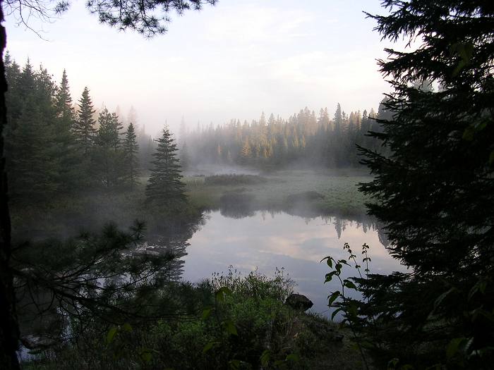
Camp 1 (about 6:30 AM) at the P55 camp on the Upper Nip.
Detail (Sunday, 5/29/05):
It was still fairly chilly at 6:30 AM in the morning when I got up so there were no bugs for my first cold Pop Tart and cup of coffee. By the time I woke up my daughter, at about 7:30, it had already warmed up enough that the mosquitoes were starting to arrive. On this trip we went back to making Starbucks French Roast coffee in my Lexan French press. If you are a coffee lover, as Emily and I both are; this is the only way to make your coffee. Along with the coffee we had breakfast bars, cold Pop-tarts and hot oatmeal flavored with maple and brown sugar.
At 9:30 AM we departed Camp 1. We arrived at P200 at 10:45 AM that also had a campsite on an uninteresting grassy spot on a plateau surrounded by woods. The trail goes uphill to this plateau then back downhill to the put-in at the river. I thought this was just as uninteresting a campsite this year as I did last year but the grassy plateau would accommodate multiple tents if a group were paddling this route.
At 11:15 AM we made the easy P100 portage around a small rapid and then the river started to meander and narrow. At 11:45 AM we came around a tight right-turning bend and there was another campsite. Last year, there was a pair of old waders on a rock at the river’s edge but they were gone this year. Obviously the Backcountry Rangers had been through here earlier. The campsite is back about 50 meters in a very dark, deep-woods and "buggy" spot. There is also a logging road just beyond it and this campsite is one of those sites you would stay in only if you had no choice.
Below this, the river starts to really meander tightly and some points were barely wider than the canoe and we paddled through tunnels of overhanging bush branches picking up a lot of debris and spiders. There were also numerous deadfall obstacles most of which could be circumvented with minimal effort but a couple of them presented some real challenges. Emily has a few phobias and spiders are one of them. Maneuvering through this stretch was a lot of work because it required as much steering from the bow paddler as the stern. Emily put in hundreds of draws and cross-draws and I was impressed since we had only worked this out the day before. We managed to avoid most of the brush and only took a few dozen spiders into the canoe. Fortunately, Emily didn’t see most of them "drop in" because they fell in behind her and I dispatched the little arachnids before they became an issue. The 'Friends' Algonquin map doesn't show these meanders but the Algonquin Adventure Series map does.
At the start of the P240 just before Grass Lake.
This really slowed down our forward progress and we arrived at the P240 and its campsite at 3:15 PM. This was the site we stayed at last year and we stopped for a late lunch of more herbed tuna and salmon on tortilla bread, more Pringles and Clif bars (a brand of high-energy bar).
Last year we were able to put the canoes in the water further upstream because of higher water levels but on this day we had to portage to the very end of the trail because of low water. The river has a nice little current for about a hundred meters then it starts to meander into Grass Lake. We encountered three more moose both entering and departing Grass Lake. The last one we saw stood his ground in the center of the channel allowing Emily to take a couple of nice pictures (with her non-digital camera). At 4:30 PM we beached the canoe at the campsite just past Grass Lake. This was a large and comfortable spot with multiple tent sites and we went about our usual chores of setting up camp and on this night we decided we would build a fire. After the tent was up with our gear inside, we set out on a firewood hunt.
We found a downed tree back on the edge of the swamp that occupied the "backyard" of this site and it was fairly perfect in terms of age, so I assembled my folding saw and we cut off a long piece and dragged it back to camp to be cut down further. This fire was near perfect and we were able to burn up much of our paper garbage that we had been transporting. As we did the night before, we dined in the tent finishing off the Shiraz and working our way into the Merlot.
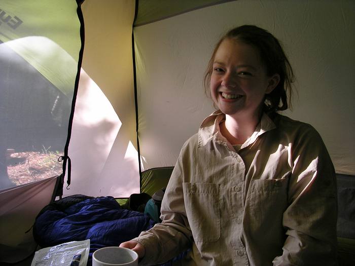
Dining in the tent at Camp 2 (just past Grass Lake).
Detail (Monday, 5/30/05):
As always I was up by 6:30 AM getting the stove going for coffee. My Whisperlite had been working perfectly since that first night and this is also the personality of this stove. It always messes with me once and then it works perfectly thereafter. I constantly threaten to throw it out and buy something else but I’m going on my fifth paddling season with this little stove and, at this point, I doubt if I will ever get rid of it.
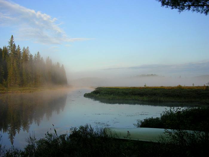
Shooting back toward Grass Lake at Camp 2 (at 6:30 AM).
We departed Camp 2 a little earlier than normal at 8:30 AM because this was the day we had to do the crux portages on this loop. The river maintained its width and gently curving personality right up to the junction with Loontail Creek.
We approached our turnoff onto Loontail Creek at 8:50 AM. One word of caution . . . this creek just flows into the Nip like any other feeder creek along the marsh and it was no problem for me this year because I remembered the turn from last year. The turn-off to Loontail Creek is approximately 1500 meters beyond the campsite (located just past Grass Lake). If you find yourself making a hard left turn and heading due north by northwest, you have passed your turn into Loontail Creek. When you make the right turn into Loontail Creek, there is dry land and forest on your left and marsh on your right and if you are navigating by compass you will be heading south by southeast.
At 9:30 AM we had to paddle up and over a semi-constructed Beaver dam that was adjacent to the only campsite on Loontail Creek. This was a small site exposed to sunlight but backing up to forest. At 10:15 AM we arrived at P845 for the portage over to Latour Creek.
This portage and the next are the most difficult of all the 'ports' on this loop. It's a long uphill for the first 400(+) meters and the first 100 meters goes up quite steeply. Last year, there was a lot of blowdown on this trail but the Rangers had cleared it all out and this portage was considerably easier. At about the halfway point, the trail crossed a logging road and continued up in elevation for another 50 meters before it leveled out and then it started down all the way to the put-in at Latour Creek. Most the difficult stuff was in the first half of this trail. With packs, this trail took 20 minutes from Loontail to Latour. With the canoe, it took slightly longer. We shoved off into Latour Creek at about noon.
Latour Creek started wide enough but quickly narrowed and the last 400 meters were only one canoe in width and tightly twisting as we slowly ran out of water. At 12:30 PM, we ran out of enough water to float the boat, 10 meters from the shore and the entire take-out was black muck with many small puddles.
At the start of P1370 over to Floating Heart Lake (in full bug regalia).
We had reached the 1370 meter portage trailhead that goes over to Floating Heart Lake. Walking through this muck was completely unavoidable and we just resigned ourselves to it. This trail went up steeply for the first 400 meters and the last stretch of this uphill was very steep. Then the trail went downhill steeply into some bottom land that you needed to work yourself through carefully. Emily was working her way through a tree root complex and slipped, falling to her knees in the muck. Last year, this trail was a little easier than the P845 because it had less deadfall but this year, blowdown was not an issue so the steeper sections seemed especially steep to my daughter and I. After the bottom-land stretch, the trail went back uphill and then it was a long gradual downhill to the put-in at Floating Heart.
We were pretty beat as we reached the shore of Floating Heart Lake and there were two Backcountry Rangers cutting out a large tree that had fallen across the trail near the put-in. They asked if we had encountered any more blowdown and we told them of only one small pine tree that had come down across the trail right at the take-out. They asked if they could get at it with their hatchet (instead of lugging their chainsaw over) and I thought they could. They departed for the trailhead and Emily and I ate a Clif bar and then we headed back for our second load. I was really dreading carrying the canoe up the really steep section because I hadn’t seen anything I could lay the boat up against to take a rest. As we were going down the steepest section the rangers were returning having cut out the last deadfall. It took us a minute before we realized they were carrying our food pack and our canoe. I thanked them and said I would take it from there but they never broke stride saying there was no reason they should go back empty-handed so we turned around and followed them back. We rewarded them on the other end with a couple of our best Clif bars (they come in many flavors) which they promptly ate having never had them before.
We crossed Floating Heart Lake at about 12:20 PM arriving on the other side at 12:30. The P365 is flat and easy with only a couple wet spots and by 2:30 PM we had shoved off into Rosebary Lake. We paddled the short distance to the nearest campsite for a late lunch and decided we would push back to the car. This was a four hour paddle but because the Rangers had spared us the second trip on a tough portage we were in good shape. We finished lunch and departed at 3:30 as a light but steady rain began to fall.
We entered the Tim River at 3:40 PM taking the shortcut through the Sedge grasses where the river meets the lake. We paddled within 50 meters from a moose that was up to his knees in the water but he never even looked up at us as we slid by.
Last year we encountered four Beaver dams in this stretch of the Tim but this year we only encountered two. The first one was well developed and about one-and-a-half feet in height above the water so we had to step out onto it and drag the canoe over.
We chased one more moose out of the river and into the woods shortly before we arrived at the only marked portage on this stretch of river.
At 5:45 PM we came to the P120 'port' which bypassed a steep rapids filled with rock and tree debris. This trail went up a steep embankment for about 45 feet but has had logs strategically placed to form a sort of giant's staircase. This staircase served two purposes, the first being to stop erosion of the embankment and the second to aid canoeists in the portage up this steep slope. The put-in was a large impoundment filled with semi-submerged grass islands and snags.
Last year we took the wrong channel out of this impoundment and lost 45 minutes back-tracking but this year, we lost no time entering the proper channel at the northwest corner of the impoundment and by 6:15 PM we were paddling out onto Tim Lake.
Back where the impoundment had rejoined the river, there was a vertical cliff face with a giant Pine precariously attached to it. This tree had to be at least 300 years old and it was really something to see. There were several of these old trees attached to rock faces along this loop and I continue to be amazed that they can tenaciously hang on century upon century.
Tim Lake was completely empty of fellow canoeists on this day and there were ominous dark clouds forming behind us and south of us. We could hear rumblings of thunder some distance off and I wasn’t sure that we would make it to the take-out before it hit us. The overcast sky got darker and darker and the setting sun cast a yellow glow on the river and forest and it was actually quite beautiful. It had been raining lightly off and on ever since we had left Rosebary Lake but it was not raining hard enough for rain gear and, in fact, the light rain felt pretty good on our fully clothed bodies.
We arrived at the take-out at 7:25 PM and wasted no time stowing our gear and loading the canoe up onto the roof of the car. There were no other vehicles in the parking lot. By the time we were pulling out, it was raining a little harder and I thought we were in for a real deluge but we apparently were moving away from it because we drove into the sunset and clear skies.
We went back into Huntsville and the Rainbow Inn; got cleaned up and had dinner at the Cottage Restaurant (again). The next day, May 31st, we had a leisurely breakfast because Algonquin Outfitters didn’t open until 10:00 AM. By 10:30 we had dispensed with the canoe and by 6:30 PM we were back home in Birmingham (Michigan).
Trip Summary
This year on the Tim-Nip loop, the key trip factors were lower water levels and peak biting insect season. The lower water created more solid obstacles to negotiate but we never bottomed out to the point we had to exit the canoe and walk it through. There were also more beaver dams on the Nip (and less on the Tim) but I don’t know what the determining dynamics are for beaver dam creation. Perhaps every year this situation is different. I really don’t know.
As for the insect situation, I think you could make this trip in early to mid-May and there would be no blackflies or mosquitoes. We just happened to hit it at peak. I really love this sport and it takes a whole lot more than a few hundred thousand insects to dampen my enthusiasm. My daughter also has the perfect personality for these sorts of challenges and she was able to overlook the fact that we had to wear our headnets any time we were outside the tent.
This is a wonderful time to be in the park because it feels like you have it to yourself (which you more or less do) and it is so alive with flora and fauna. We saw nine moose on this trip which is the most I have ever seen on any one trip anywhere in the Canadian wilderness. This is not an easy route by Algonquin standards but it is fairly easy compared to some of the trips I’ve done outside of the park in other, more remote, parts of Canada. What I like the most about this loop trip is that it passes through a little bit of everything Algonquin has to offer.
We have done this trip two years in a row and each time we did it in three days. If you take a fourth day, you can start late and end early each day and really absorb the beauty of this park.
© Copywrite by Neil E. Miller
June 27, 2005