|
|
|
|
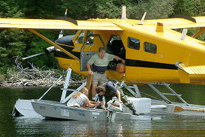
 Tuesday, August 19th, 2003 . . . . . Tuesday, August 19th, 2003 . . . . .I've added a new set of 38 photos, from a short 5 day trip I took last week, out of the Cache Lake access point. It wasn't a long-haul, just a lazy time. There'd been a really wet spell just prior to me heading out. So the fungi and toadstools were blooming everywhere. Delano Lake was fresh territory for me. It's a nice little lake, with a solitary campsite that looks south down its length. After two nights on Delano, I back-tracked via Cache Lake for two nights on Head Lake, having been there three years ago. The wildlife viewing wasn't the greatest. But hey, any time in Algonquin is a good time! You can check the pictures out in the "Photos/Photo Shows" menu under "Delano and Head Lakes". 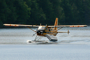 Saturday, August 16th, 2003 . . . . . Saturday, August 16th, 2003 . . . . .Mid-day of this past Tuesday (Aug. 12th), I was lounging on the rocks infront of my tent overlooking Delano Lake, reading a book. As is occasionally the case in Algonquin, a float plane flew overhead. However, this time it circled around behind the hills and returned low down the creek valley behind my campsite and landed on the lake. After turning around, it taxied right into my bay. A small boat was unfastened from the float-struts and was paddled to the site.
My visitor was Erica Genrich, a summer student working with the Algonquin Fisheries Assessment Unit. She was bringing the boat in and would stay ashore while the pilot and the other student (Paul Woodard) flew back to base to bring in the rest of their project equipment, which was to be stashed by my site in the boat overnight. The next day they'd be starting a sampling study of Delano's fish. Their daily access route was to be a narrow foot-trail directly from Cache Lake. I had just happened to walk the trail earlier in the morning, having noticed its flourescent red markers directly behind my site.
After the plane took off we got into a very interesting conversation, sharing our Algonquin experiences ... she as a summer student now spending her fourth summer working at the park, with two years yet to go at university ... and me as an oldster making periodic trips here through the summer and maintaining this website. Erica made special mention of a new booklet being published containing the results of the 'Bathyspheric' study of several Algonquin lakes. When the plane returned with the equipment, Erica and Paul unloaded it into the boat and secured it all to the shore. While the fly-in had been an enjoyable break in a typical Algonquin day, it's uniqueness wasn't to end there.
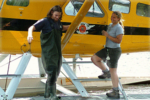
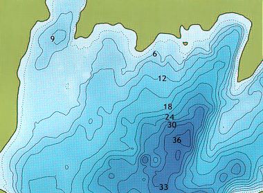
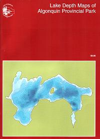
The next day, as I walked back to the landing of the portage between Delano and Hilliard Lakes to 'double-carry' my packs, I heard voices around the bend. I called out 'Hello' and was greeted with 'Is that Barry?'
It was Paul and another fellow carrying my packs. The other fellow explained they were helping to shorten my carry and had brought along a 'fresh-off-the-presses' copy of the new 'Lake Depth Maps of Algonquin Provincial Park'. He was Greg Betteridge (co-author of the book). Erica had visited the website later the previous day (at their base-office) and had brought it to Greg's attention. We chatted for a while and Greg autographed the book for me. All-in-all another enjoyable encounter. The book opens with an explanation of the modern methodology and technology (a depth sounder linked to GPS) employed in acquiring the depth data. There are 26 high definition colour maps of 23 lakes. It's appropriate to list the lakes here, since their information is anticipated to be of particular interest to fishermen. These maps are a vast improvement over those produced in the late 1970's.
  |
|
Barry Bridgeford (Site-editor) |