 Three Mile Lake Campsite #12
Campsite Location
GPS - UTM location (optional): N45° 59.048' W78° 53.886'
South/east site on island with 3 sites
Landing
Topography of under-water approach: Rock and silt.
Impediments to disembarking from and/or unloading a canoe: Small loading area, requires you to stand in water or balance on rocks.
Topography leading to tent sites: Steep, short climb to site.
 |
|
| - Landing is to the right of the campsite sign. | |
 |
|
| - Parking for a couple of canoes, a climb of 1.5m from the water. | |
Campsite
Regular or low-maintenance: Regular
Size of open ground area: 12m x 8m.
Extent of tree cover: 40%.
Degree of levelness: Level.
Number of tent sites: 3.
North exposure: Trees.
East exposure: Lake.
South exposure: Trees and lake.
West exposure: Trees.
 |
|
| - Tenting area at back of firepit. | |
 |
|
| - Tenting area on south side of site. | |
 |
|
| - Fallen trees shown from the back of the site. | |
 |
|
| - Firepit and north tent area. | |
General description: A large and level site. A tent could be pitched almost anywhere on the site because of the levelness, except that the fallen trees that bisect the site remove some of the tenting options. A small clearing at the front of the site is good for storage of a couple of canoes.
Overall accessibility: Not an easy take out or put in and only one canoe at a time. Site is level with few obstacles, however, the tent pad on the south side of site requires stradling a couple of fallen trees to get to.
 |
|
| - Campsite Diagram. | |
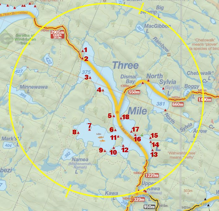
Thanks to Jeffrey McMurtrie of Jeff'sMap for supplying the base-layer map component by Creative Commons licensing.
Submitted by: Chris Taylor .. Visited May, 2015 .. Submission October 19th, 2015