 Rain Lake Campsite #4
Landing
Topography of under-water approach: Small shallow sand and gravel beach.
Impediments to disembarking from and/or unloading a canoe: Bow of landing canoe is right at base of rising trail.
Topography to tent sites: Steep dirt rise of almost 20', to actual campsite.
Campsite from the water ...

![]()
Landing and trail up to campsite ...

![]()
Looking down to the landing ...

![]()
Campsite
Regular or low-maintenance: Regular.
Size of open ground area: 15 x 50'.
Extent of tree cover: Tall trees form a full canopy.
Degree of levelness: Level around firepit.
Number of tent sites: 3 (either side of and close behind firepit).
North exposure: Forest, lake and shoreline growth.
East exposure: Forest.
South exposure: Forest.
West exposure: Forest, lake and shoreline growth.
Firepit area ...

![]()
Looking north across the width of the campsite...

![]()
Tentsite at the north end of campsite...

![]()
View across the lake...

![]()
General description: It's enclosed by large trees and has neither sunning rocks nor any open view. Its only real positive is its level tentsites close around the firepit.
Overall accessibility: Dirt trail up from water is quite steep and in rainy conditions would be a definite challenge.
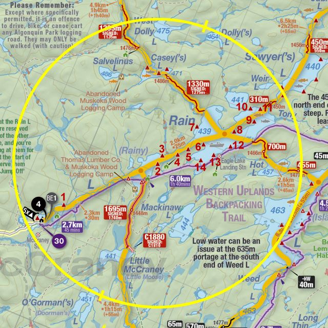
Thanks to Jeffrey McMurtrie of
Jeff'sMap for supplying the base-layer map component by Creative Commons licensing.
Submission September 2022 by Barry Bridgeford .. visited September 2022