 Rain Lake Campsite #13
Landing
Topography of under-water approach: Small sandy beach.
Impediments to disembarking from and/or unloading a canoe: Rocks and bushes on either side.
Topography to tent sites: Gentle rise of approx. 6'.
Landing area and campsite from the water ...

![]()
Looking out across the landing area ...

![]()
Campsite
Regular or low-maintenance: Regular.
Size of open ground area: 50' x 50'.
Extent of tree cover: Tall evergreen trees over both fire-pit and tentsite area. Open under overhead canopy.
Degree of levelness: Tentsite areas are level.
Number of tent sites: 3.
Fire pit is central in the campsite and has a good view of the landing area.
Point of Interest: Between two of the tentsites is an old 20 x 20' concrete foundation that sticks up a few inches and is overgrown by small trees.
It's original building was probably used in conjunction with the old "Eagle Lake Landing Station" on the nearby old railway, the roadbed of which now serves as part of the Western Uplands Backpacking Trail.
Section of the old building foundation ...

![]()
North exposure: Lake view and some shoreline growth.
East exposure: Forest and trails to thunderbox and area hiking trail.
South exposure: Local trees and bay that separate peninsula and campsite from the mainland.
West exposure: Local trees, beyond which is open rock point with view across lake. Late afternoon sun filters into the campsite, drawing one to enjoy the sunset from the open rock point.
Small tentsite looking west by the shore ...

![]()
Larger tentsite by old foundation, with trail beyond to open rock point ...

![]()
Largest tentsite area at east side of campsite ...

![]()
View looking north from the firepit ...

![]()
General description: Large with, with room for three tents. While during the day, odd voices can be heard of hikers on mainland trail, the campsite is quite attractive and spacious.
Overall accessibility: Easy.
Morning view from campsite's open rock point, to the west ...

![]()
Morning view from campsite's open rock point, to the north...

![]()
Afternoon view from campsite's rock point, looking south to the mainland ...

![]()
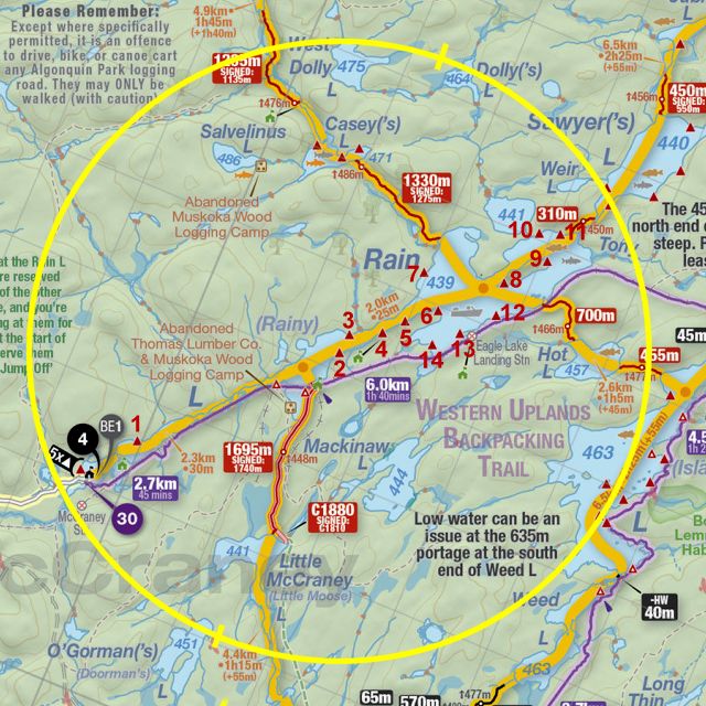
Thanks to Jeffrey McMurtrie of Jeff'sMap for supplying the base-layer map component by Creative Commons licensing.
B
Submission September 2022 by Barry Bridgeford .. visited September 2022