 Rain Lake Campsite #11
Landing
Topography of under-water approach: Approach is over curved rock.
Impediments to disembarking from and/or unloading a canoe: Curved rock makes unloading and disembarking difficult.
Topography to tent sites: Gentle rise to rear of campsite.
Campsite and landing from the water ...

![]()
Looking down into the water of the landing ...

![]()
Looking across the landing area, to the west ...

![]()
Campsite
Regular or low-maintenance: Regular.
Size of open ground area: 100 x 100'.
Extent of tree cover: Some tall trees at rear, but generally open to the sky.
Degree of levelness: Only somewhat level.
Number of tent sites: 2.
Fire pit is close to the water and fully open to the sky.
North exposure: Forest.
East exposure: Lake.
South exposure: Lake.
West exposure: Trees.
Looking back down-trail to the landing, across the lower part of the campsite ...

![]()
Looking across the sloped, rocky, grass area between firepit and sign...

![]()
Sloped small tentsite behind grass area ...

![]()
Better small tentsite back amongst the trees ...

![]()
General description: Very 'spread-out' sloped and open, with a great view across the lake.
Overall accessibility: Once you manage to disembark, it's quite accessible.
Note: Portage to Sawyer Lake appears close on map, but is actually a distance away.
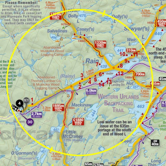
Thanks to Jeffrey McMurtrie of
Jeff'sMap for supplying the base-layer map component by Creative Commons licensing.
Submission September 2022 by Barry Bridgeford .. visited September 2022