 Rain Lake Campsite #10
Landing
Topography of under-water approach: Sandy bottom interspersed with some muck.
Impediments to disembarking from and/or unloading a canoe: Bring canoe parallel to shore.
Topography to tent sites: Steep rise of almost 15', to actual campsite.
Campsite and landing from the water ...

![]()
Side view of the landing ...

![]()
Looking down on to the landing ...

![]()
Campsite
Regular or low-maintenance: Regular.
Size of open ground area: 40 x 50'.
Extent of tree cover: Tall trees form a full canopy.
Degree of levelness: Only somewhat level around firepit. But tentsites, which are located to the west, are level.
Number of tent sites: 3.
North exposure: Forest.
East exposure: Trees.
South exposure: Lake and shoreline trees.
West exposure: Trees.
Main sloped part of campsite with firepit ...

![]()
Level tentsite (1/3), amidst forest trees...

![]()
Level tentsite (2/3), amidst forest trees...

![]()
Level tentsite (3/3), amidst forest trees...

![]()
Second landing area, west of mail one...

![]()
General description: Tentsite area is at a distance from firepit. View of the lake is limited. No sunning rocks or sunset view.
Overall accessibility: Once you get up the slope, the tentsites are quite accessible.
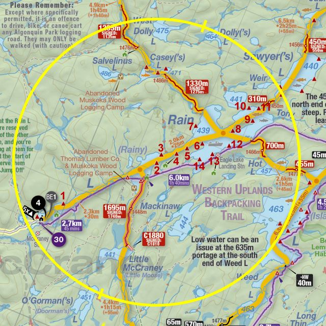
Thanks to Jeffrey McMurtrie of
Jeff'sMap for supplying the base-layer map component by Creative Commons licensing.
Submission September 2022 by Barry Bridgeford .. visited September 2022