 Pen Lake Campsite #4
Landing
Topography of under-water approach: Shallow sand beach with scattered rocks.
Impediments to disembarking from and/or unloading a canoe: None.
Topography to tent sites: Gentle 10 foot grade up to campsite.
Sandy beach landing amidst some large rocks, with view of the north bay ...

![]()
Looking down from the campsite to the landing ...

![]()
Campsite
Campsite maintenance: Regular.
Size of open area: Entire north end of island is open under canopy of mature trees. Trunks of these trees grow spaced about.
Extent of tree cover: 100%.
Degree of levelness: Large areas are level.
Number of level tent sites: Many.
North exposure: Shoreline trees and shrubs.
East exposure: Shoreline trees and shrubs.
South exposure: Mature tree trunks and canopy.
West exposure: Shoreline trees and shrubs.
Firepit with the gap in the trees beyond, leading down to the landing ...

![]()
Looking over the tentsite area, past the firepit toward the shoreline trees ...

![]()
Someone has equipped the outhouse with a secure modern seat and lid ...

![]()
The campsite's 'island' is connected to the mainland (where firewood can be gathered) by this north-facing beach (photo 2012) ...

![]()
General description: The campsite is encircled by deciduous shoreline shrubs and trees. It's canopy of tree-tops extends to the south end of the 'island' where another campsite is located, from which privacy is provided by the distance between them. However, these campsites are served by a pair of 'outhouses' which are located somewhat close together.
Overall accessibility: OK.
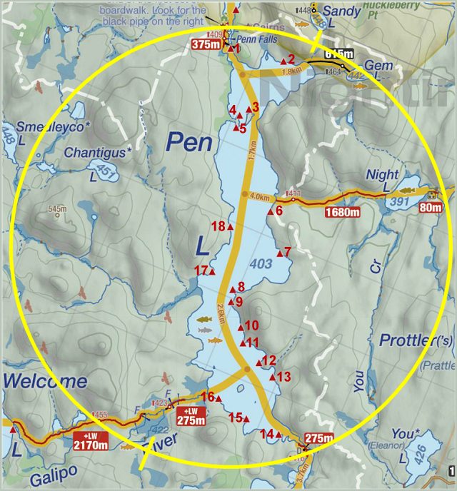
Thanks to Jeffrey McMurtrie of Jeff'sMap for supplying the base-layer map component by Creative Commons licensing.
Submitted by Barry Bridgeford .. Visited Sept. 2017 .. Submission Oct. 2017