 Pen Lake Campsite #1
Landing
Topography of under-water approach: Shallow and gently sloped.
Impediments to disembarking from and/or unloading a canoe: None.
Topography to tent sites: A very easy slope up to the campsite.
South into Pen Lake, landing is to the left ...

![]()
Campsite
Campsite maintenance: Regular.
Size of open area: Quite large.
Extent of tree cover: Moderate.
Degree of levelness: Poor.
Number of level tent sites: Three small ones.
North exposure: Exposed rock.
East exposure: Forest.
South exposure: A few trees block the lake.
West exposure: Clear view of the Pen-Rock portage.
Very small semi-level tentsite right next to the landing, with southern exposure to Pen Lake ...

![]()
General description:
Pros: Easy landing; rock formations make great tables/counters; quick access to Pen Falls; relatively short paddle to Rock Lake.
Cons: We visited in early Spring which meant that a good portion of the level tent sites were situated in wet-boggy ground. As such, we were relegated to one of the three "passable" alternate tent sites. The thunderbox is far and difficult to locate .. to the northeastt up two definite changes in elevation. Due to the remoteness of the thunderbox and the site's location relative to the portage trail, human waste abounds behind every potential cover.
Avoid this campsite!
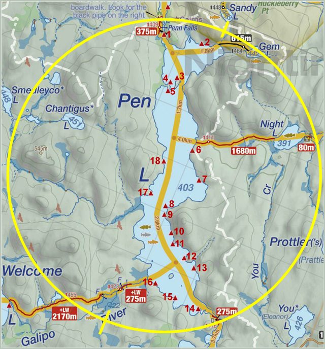
Thanks to Jeffrey McMurtrie of Jeff'sMap for supplying the base-layer map component by Creative Commons licensing.
Submitted by Paolo Benvenuti .. Visited May 22nd 2019 .. Submission May 31, 2019