 Amable du Fond River Campsite #2
Campsite Location
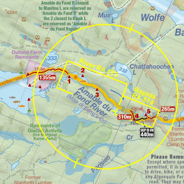
GPS - UTM location: N46° 03.189' W78° 57.114'
Located on north side of river, approx. 1/2 Km east of portage to Manitou Lake
Landing
Topography of under-water approach: Small and medium sized rocks covered in silt.
Impediments to disembarking from and/or unloading a canoe: None, step into ankle deep water, or directly to shore from the canoe.
Topography leading to tent sites: Short, unimpeded carry.
 |
|
| - Unimpeded access to shore. | |
 |
|
| - Room for a couple of canoes to load/unload. | |
Campsite
Regular or low-maintenance: Regular
Size of open ground area: 10m x 5m.
Extent of tree cover: 75% mostly at rear of site.
Degree of levelness: Sloped slightly from back to front.
Number of tent sites: 2 levelled sites.
North exposure: Trees.
East exposure: Trees.
South exposure: Open view of river.
West exposure: Good view of river from front of site, trees at back.
General description: Small site, good for 2 x 3-man tents, there is another somewhat sloped and unlevel area could be used for a 3rd tent. Exposed to wind from the west and south. Front of site is open to sun for most of the morning and early aftermoon.
Overall accessibility: No issues.
 |
|
| - Looking from thunderbox trail at back of site. | |
 |
|
| - Tentpad closest to the water. | |
 |
|
| - Campsite sketch. | |
Thanks to Jeffrey McMurtrie of Maps By Jeff for supplying the base map.
Note: This area is actually comprised of 2 reservation areas .. "river" area with 3 campsites and "rapids" area with 2 campsites.
Submitted by: Chris Taylor .. Visited May, 2015 .. Submission October, 2015